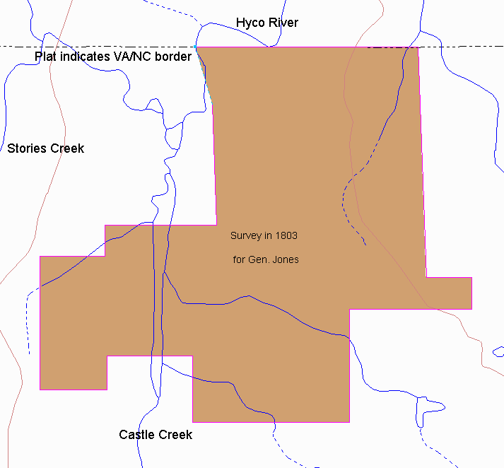
| On December 5, 1803 a surveyor for General Jones
prepared this original plat. A recreation of the original plotted against the
present day geogaphy can be seen below. The significance was the fact that it
abutted the Virginia/North Carolina border, specifically indicated where the Hyco crossed,
and mentions Moses Walker's property.
This provides a starting point for placing the Walker properties. Most of this land was in the Roger Atkinson family in the late 1700s and Joseph Jones married his daughter.The description of the plat was: "Beginning at a Post Oak in the county line thence with D. Brooks line S2ºE 412 poles to John Brooks corner pine thence with said Brooks line E 81 poles to a post oak thence S 57 poles to John Lawson's corner white oak thence on Lawson's line west 218 poles to a corner pine thence south crossing Rambo's Branch 202 poles to a corner ash thence west 280 poles to a corner pine thence west 280 poles to Walker's old line corner down formerly a hickory thence on Walker's line north crossing Keedle's Branch 119 poles to corner pointers formerly a dogwood thence west crossing Castle Creek 153 poles to a small hickory thence south 60 poles to a white oak fallen down thence west 120 poles to a hickory sapling in Dixon's line formerly a red oak thence with said line N 238 poles to a pine formerly a hickory in Bailey's line thence with said line E 116 poles to a red oak thence N 56 poles to a pine thence E 200 poles crossing Castle Creek to a white oak thence north 2ºW 216 poles to Luke Robertson's spring branch thence down said branch to Hico to the county line thence with the county line E crossing Hico twice 398 poles to the beginning." |
|
